SPECIAL EXHIBITION 2015
Building the Olmsted Plan
Curated by HLFM director Pierce Rafferty
In the early 1920s, two leaders of the second generation of Ferguson owners, Henry L. and Alfred L. Ferguson, turned their attention to the mostly undeveloped eastern two-thirds of the island. Operating as officers of the Fishers Island Farms, Inc., the company that had succeeded the E. M. & W. Ferguson company, they shipped almost all the dairy cows off the island and shut down the island’s farms. Contemplating an entirely different use for the former pastureland, they hired Frederick S. Ruth—a real estate developer known for his successful resorts—to examine the possibilities of creating a new residential summer colony on Fishers Island’s east end. Ruth’s report stated:
“There is no doubt in my mind that a high-toned development of the park [the east end of Fishers Island], including a residential club and cottage colony, will not only increase the present attractiveness of the Island, but will bring in a great many desirable new summer residents who want a greater privacy and better golfing facilities than now afforded.”
The Farms endorsed Ruth’s report and accepted his recommendation to hire Frederick Law Olmsted, Jr., to design the overall plan, and Seth J. Raynor to build its new golf course. Olmsted, Jr., the son of the legendary designer of Central Park in New York City, was himself a renowned landscape architect based at the same firm in Brookline, Mass., that his father had founded.
In June 1926, Olmsted’s firm issued its preliminary plan for the subdivision of the east end. Mr. Ruth had by that time signed up 180 members for the new club (not including spouses or children). 100s of workers were soon busy building the infrastructure necessary to support the new development. Engineer Donald Hine, then manager of the Fishers Island Farms, Inc., photographed many aspects of the east end work as it progressed. His children, C. Clarkson Hine and Charlotte Hine Sobeck, generously donated to the Museum their father’s unique photographic record of east end construction. Mr. Hine’s documentation forms the core of this “Building the Olmsted Plan” exhibit.
A Blank Slate
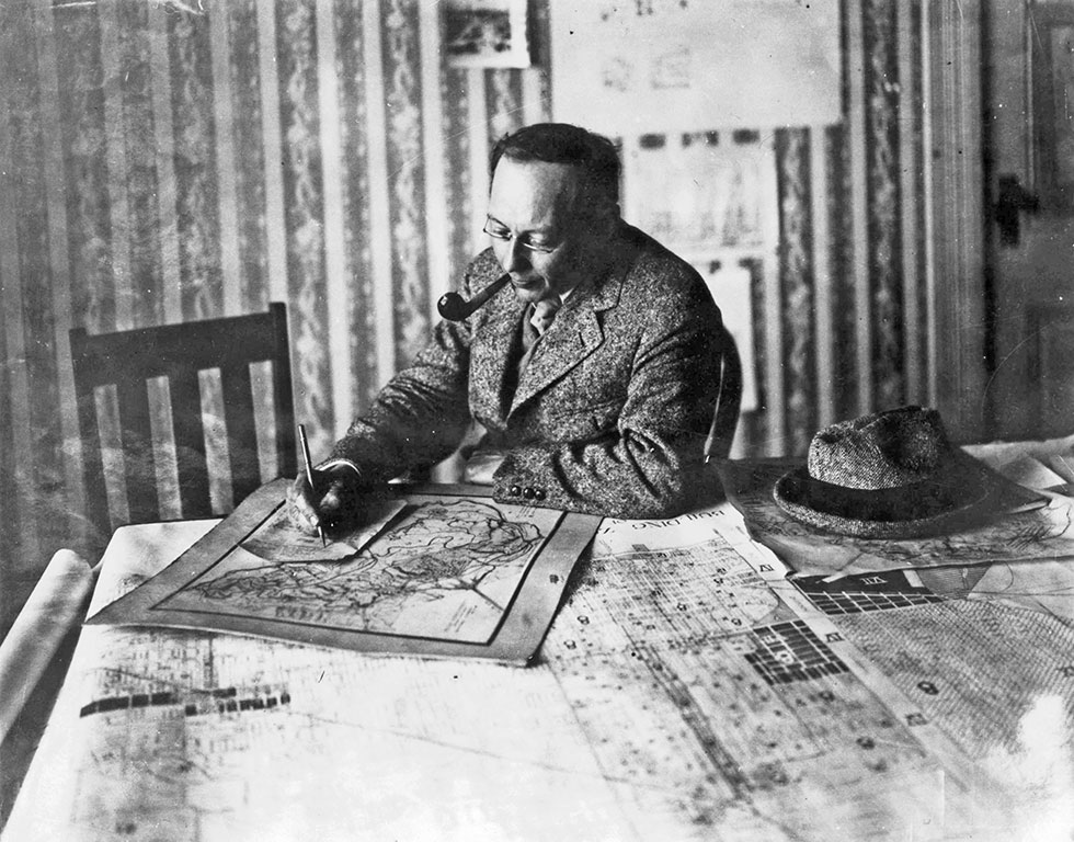
Frederick Law Olmsted, Jr., at the drafting table, Palos Verdes, California
Circa 1925
Courtesy of National Park Service, Frederick Law Olmsted National Historic Site, Brookline, Mass.
Olmsted, the son of the celebrated designer of Central Park, was a renowned landscape architect in his own right. Hired in 1924 by the Fishers Island Corporation, he crafted the residential subdivision plan for Fishers Island’s private east end that is known today as “The Olmsted Plan.”

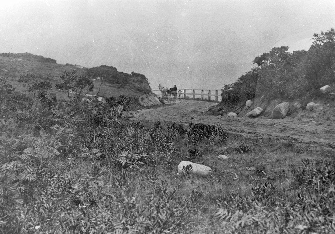
Dirt road amidst bare bluffs on the south shore, east end, Fishers Island, NY
Circa 1910s
Museum Collection
Centuries of clearing and cropping by farmers and livestock respectively left Fishers Island’s landscape remarkably bare. Olmsted was presented with clear and unobstructed vistas as he plotted ideal locations for the new residential colony within “the park.”
This view shows a low road along the water as it approached the bluffs at the west end of Isabella Beach. Only traces of this road remain today.

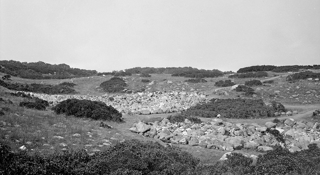
Stone walls crisscrossing future site of the Fishers Island Club’s golf course, Fishers Island, NY
Circa 1906
Photograph by Col. Charles D. Parkhurst
Courtesy of the New London Maritime Society
These long-forgotten stone walls are a stark reminder of the extensive livestock farming that was the dominant economic activity on Fishers Island for most of its post-settlement history.
The stone walls are traversing the end of the 15th hole (at right) and the beginning of the 16th hole (at left). Note the US Life-Saving Service station and boathouse in center-right background. The station, built in 1904, became a US Coast Guard station in 1915. Sold by the US Government in the mid-1950s, it today is the seasonal residence of Mrs. Rolla Campbell.
New Infrastructure for the East End
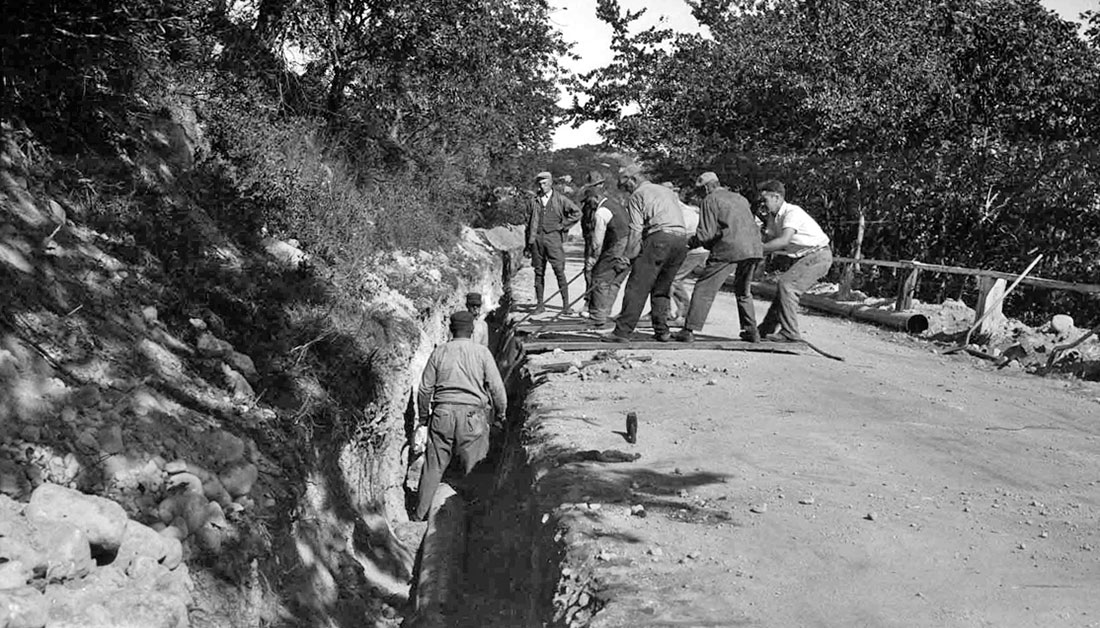
Prior to the construction of a new east end asphalt road—begun in the fall of 1909 and completed by the fall of 1912—only horse-drawn buggies and wagons were allowed to travel on the narrow and winding east end road.
The road project began almost immediately after the Fergusons succeeded in buying out the property of the Fishers Island brickyard in 1909. (The brickyard shut down because the water table had been reached in the clay pits.) With that noisy and unsightly impediment to habitation by summer residents removed, the Fergusons began to tout the east end as a site for homes. Paving and improving the dirt road was the first step in a long deferred plan to bring a residential development to the east end.
Single buggy on dirt road above Isabella Beach, Fishers Island, NY
Circa 1905
Museum Collection
For safety reasons, the Ferguson owners simply banned all automobiles from traveling past the Poultry Farm Fence located at the base of the hill on the approach to today’s Gate House. (This fence line later became the boundary of the private section of the island.) With the road construction progressing eastward, some automobile traffic was permitted into parts of the east end beginning in 1910.
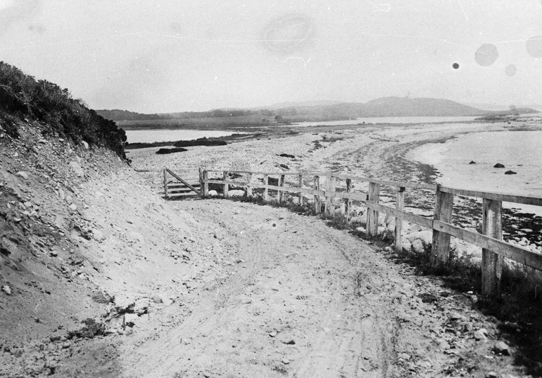
Dirt road along south shore approaching Island Pond from the west, Fishers Island, NY
Circa 1905
Museum Collection
This long-abandoned road, seen here at shore level below the Kelley-Wooten house, once looped around the south side of Island Pond until it intersected with the main road at the eastern end of Island Pond near today’s driving range shack. Chocomount Hill is prominent in the background.
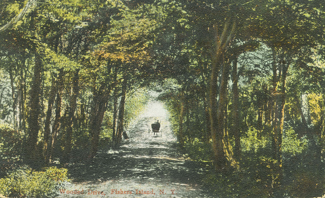
Wooded Drive, Fishers Island, N.Y.
Circa 1908
Postcard published by A.C. Bosselman Co.
Museum Collection
The wagon is passing through the scenic Brickyard woods over a rustic dirt road that would soon be replaced by a more modern asphalt road. The new road was summarized in a Fishers Island Farms, Inc., inventory report published in 1926: “East End Main Highway Road is a Tarvia road extending from the Gate at the Poultry Farm to the East End Farm having a length of 26,150 ft. and a width of 12 and 14 ft.” Construction of the asphalt East End Main Road, moving from west to east, took place each fall in 1909, 1910, 1911 and 1912.

Map Showing Present & Proposed Development of Fishers Island, N.Y.
Circa 1926
Published by Day & Zimmerman, Inc., Engineers
Museum Collection
The Olmsted Plan led to widespread road construction on Fishers Island. Note the extensive road network marked in red that reveals proposed routes for new roads, including some at the west end. Not all of these spurs were built, but the Olmsted Plan envisioned up to 400 new houses through the gate that needed road access. Consequently, most of the side roads and loops in use today at the east end were constructed between 1925 and 1929 as part of the Olmsted Plan.
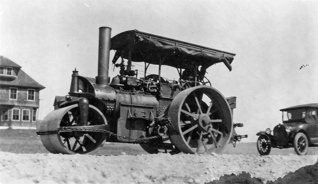
Steam-powered road construction roller, Fishers Island, NY
Circa 1927
Museum Collection
This machine and others like it would have been a common sight on Fishers Island in the mid-1920s.
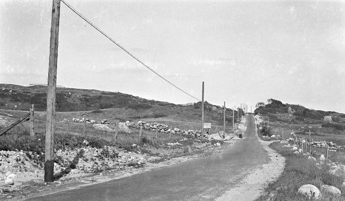
New telephone poles and wires lining the east end main road near Chocomount Hill
June 3, 1926
Photograph by Donald F. Hine
Museum Collection. Donated by C. Clarkson Hine and Charlotte Hine Sobeck
This photograph provides another reminder of how great the tree and vegetation growth has been on Fishers Island in the 90-plus years since grazing cattle and sheep were removed from the east end’s landscape.
Please note the exposed rim of the new Chocomount Hill (“Top of the World”) reservoir just to the left and behind the telephone pole in far-left foreground.
Modern Filtration Plant and Water System
The establishment of a residential colony at the east end necessitated the construction of a modern filtration plant and water system that could deliver treated water of high quality to the swelling population at both ends of the island.
Although the exact completion date is not known, the published target date was October 1, 1927. The filtration plant aerated, treated, filtered, and ultimately stored finished water in a clear tank prior to distribution by the pumping station to both ends of the island.
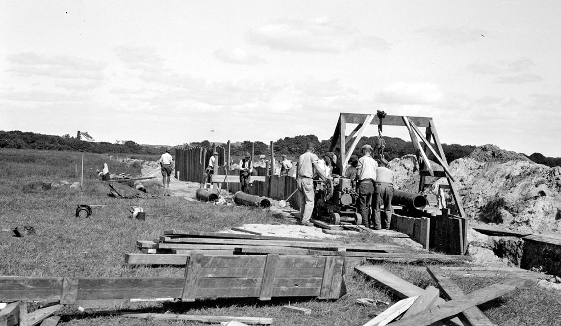
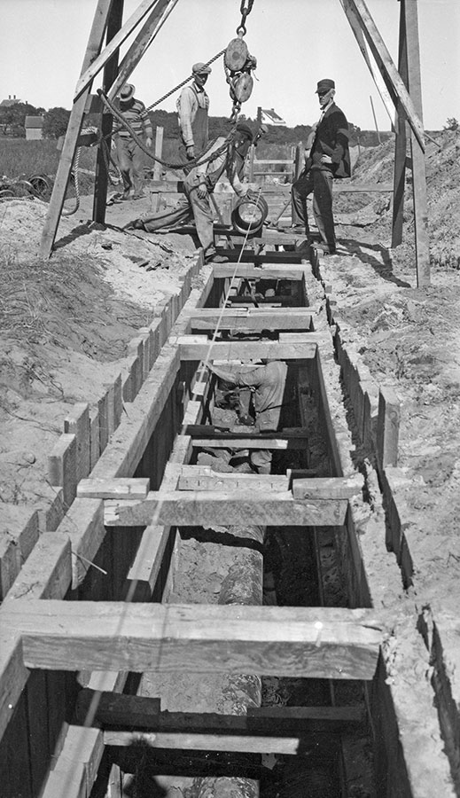
Workers laying 12-inch water pipe in a sheathed trench across Middle Farms Flat, Fishers Island, NY
September 19, 1925
Photograph by Donald F. Hine
Museum Collection. Donated by C. Clarkson Hine and Charlotte Hine Sobeck
The 12-inch pipe being laid here was part of a new system of cast iron pipes that connected Middle Farm Pond with Island Pond (now better known as Oyster Pond).
Island Pond having previously been connected to Barlow Pond by a 10-inch cast iron pipe, the new pipe being laid here interconnected all three of the major reservoir lakes by bringing Middle Farm Pond into the system: Barlow Pond (surface area 13 acres), Island Pond (surface area 47 acres), and Middle Farm Pond (surface area 32 acres). Together there were 92 acres of fresh surface water to draw from in the initial Olmsted Plan reservoir system.
Workers laying 12-inch water pipe near Island Pond, Fishers Island, NY
September 20, 1925
Photograph by Donald F. Hine
Museum Collection. Donated by C. Clarkson Hine and Charlotte Hine Sobeck
The 1938 Hurricane breached two of the three reservoir lakes and wreaked havoc with the multi-lake reservoir system. By pumping out the salt water, spring-fed Middle Farm and Island ponds were restored as fresh water sources. After Island Pond was breached again by a hurricane in the 1940s, it was allowed to stay brackish and remains so to this day; consequently, it is an ideal spot for cultivating oysters. The pipe valve connections linking Middle Farm Pond and Barlow Pond were determined to be non-functional circa the 1960s.
Workers laying 12-inch water pipe in framed trench across Middle Farms Flat, Fishers Island, NY
September 26, 1925
Photograph by Donald F. Hine
Museum Collection. Donated by C. Clarkson Hine and Charlotte Hine Sobeck
Please note that “Falcon Hill,” the residence of Mr. and Mrs. Henry L. Ferguson, can be seen in center background. Built in 1914 overlooking Middle Farms Pond, it preceded the Olmsted plan by ten years and was the east end’s first non work-related residence. All prior east end houses had been built specifically to house workers, farmers, or surfmen at the Life-Saving Station.
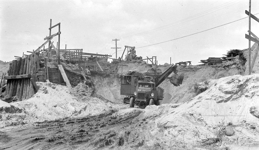
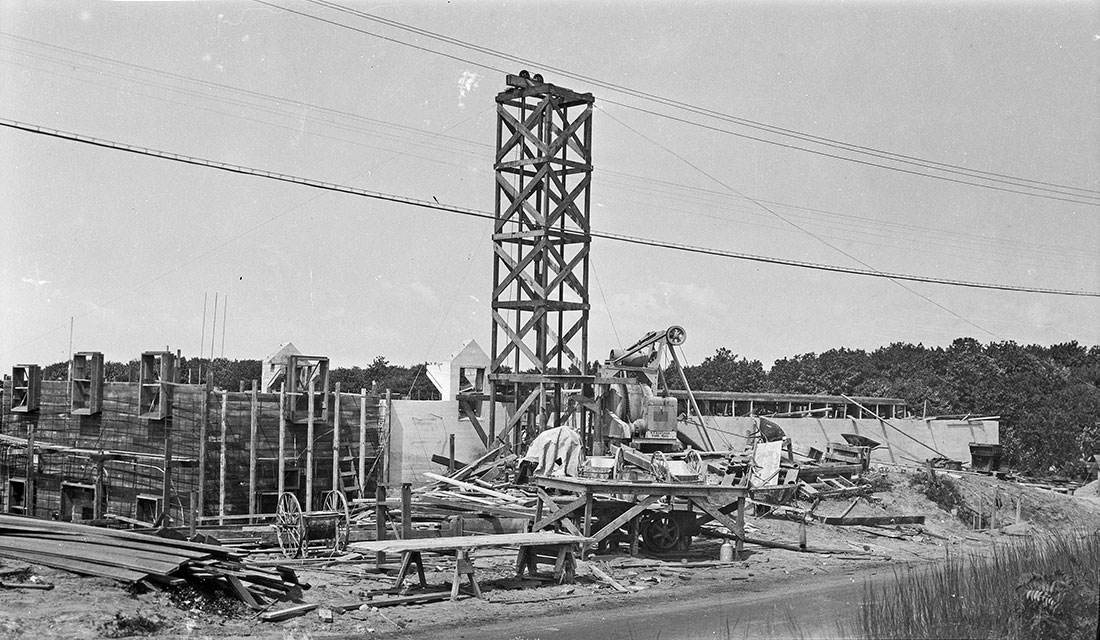
The new Filtration Plant under construction on Barlow Pond, Fishers Island, NY
Circa 1926
Photograph by Donald F. Hine
Museum Collection. Donated by C. Clarkson Hine and Charlotte Hine Sobeck
Prior to the construction of the new plant, fresh water had been pumped by the adjacent brick Pumping Station (1904) to the west end reservoir atop Bell Hill, the highest point on the west end (later site of Shillo, now Hall residence).
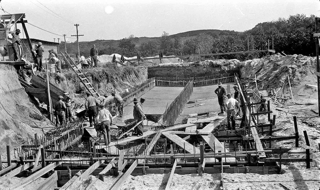
Construction of foundation for Filtration Plant, Fishers Island, NY
Circa 1926
Photograph by Donald F. Hine
Museum Collection. Donated by C. Clarkson Hine and Charlotte Hine Sobeck
Construction of exterior walls for Filtration Plant, Fishers Island, NY
Circa 1926
Photograph by Donald F. Hine
Museum Collection. Donated by C. Clarkson Hine and Charlotte Hine Sobeck
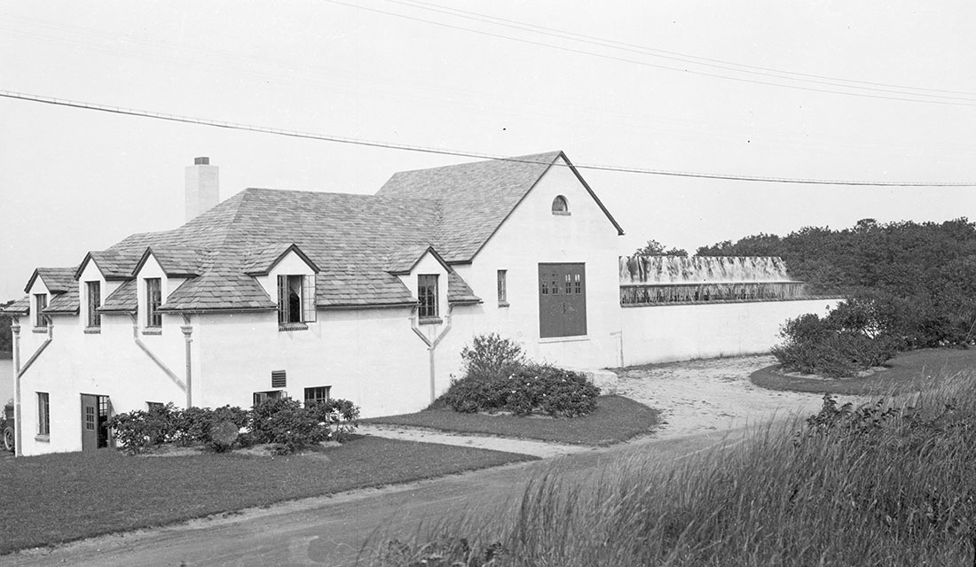
Completed Filtration Plant, Fishers Island, NY
Circa 1927
Photograph by Donald F. Hine
Museum Collection. Donated by C. Clarkson Hine and Charlotte Hine Sobeck
The Filtration Plant was designed by Parsons & Wait, Architects, Boston, Mass., the same firm that designed the Fishers Island Club’s first clubhouse and many prominent private residences built at the east end in the mid- to late-1920s.
Today it provides a supplemental service because the island’s water supply is drawn from wells at Middle Farm Flat and water is treated in a separate building at that location.
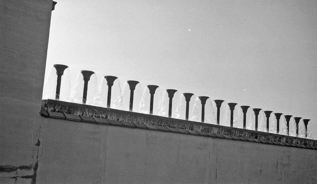
Detail view of aerators in operation, Filtration Plant, Fishers Island, NY
Circa 1927
Photograph by Donald F. Hine
Museum Collection. Donated by C. Clarkson Hine and Charlotte Hine Sobeck
“The plant consists of a low-lift pumping-station, which raises the lake water to an aerator, located on top of the coagulating basin. The water flows from the aerator to a mixing chamber within the building.” Quote from The Water-Supply of Fishers Island, N.Y. published in The American City, January 1929 issue.
The aerators are used to separate organic contaminants from the water. Soda ash and other additives coagulate with the contaminants in the mixing chamber creating a foam-like substance that is removed via a discharge tank.
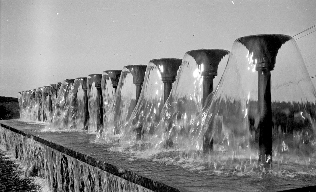
Close view of aerators in operation, Filtration Plant, Fishers Island, NY
Circa 1927
Photograph by Donald F. Hine
Museum Collection. Donated by C. Clarkson Hine and Charlotte Hine Sobeck
For many decades, children approaching the Filtration Plant in cars played a game of guessing whether the aerators would be “on” or “off” as they passed. Because today’s island water supply is drawn from wells, the water is rarely “on” anymore at the Filtration Plant.
The original spray nozzles seen here were removed in 1986 because they were no longer manufactured and therefore impossible to replace when broken. Newer model nozzles that are less architecturally distinct were installed at that time.
As part of the Olmsted Plan, Fishers Island’s second major reservoir was built atop the east end’s Chocomount Hill in the mid-1920s.
After its completion in 1926, this new “Top of the World” reservoir, located at the island’s highest elevation (136-feet above sea level), became the Fishers Island Water Company’s preferred reservoir.
It was both higher than Bell Hill and more cost effective to reach with pumped water because of its relative proximity to Barlow Pond and its newer cast iron pipe water mains. When the roof of the west end’s Bell Hill Reservoir rotted out circa the late 1950s, the Chocomount Reservoir became the island’s only major reservoir. It remains so to this day.
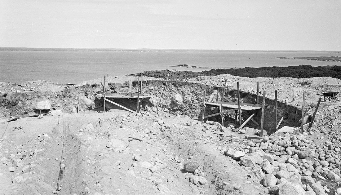
Construction site for the Chocomount Reservoir, Fishers Island, NY
Circa 1925
Photograph by Donald F. Hine
Museum Collection. Donated by C. Clarkson Hine and Charlotte Hine Sobeck

Down-angle view of the Chocomount Reservoir construction site, Fishers Island, NY
Circa 1925
Photograph by Donald F. Hine
Museum Collection. Donated by C. Clarkson Hine and Charlotte Hine Sobeck
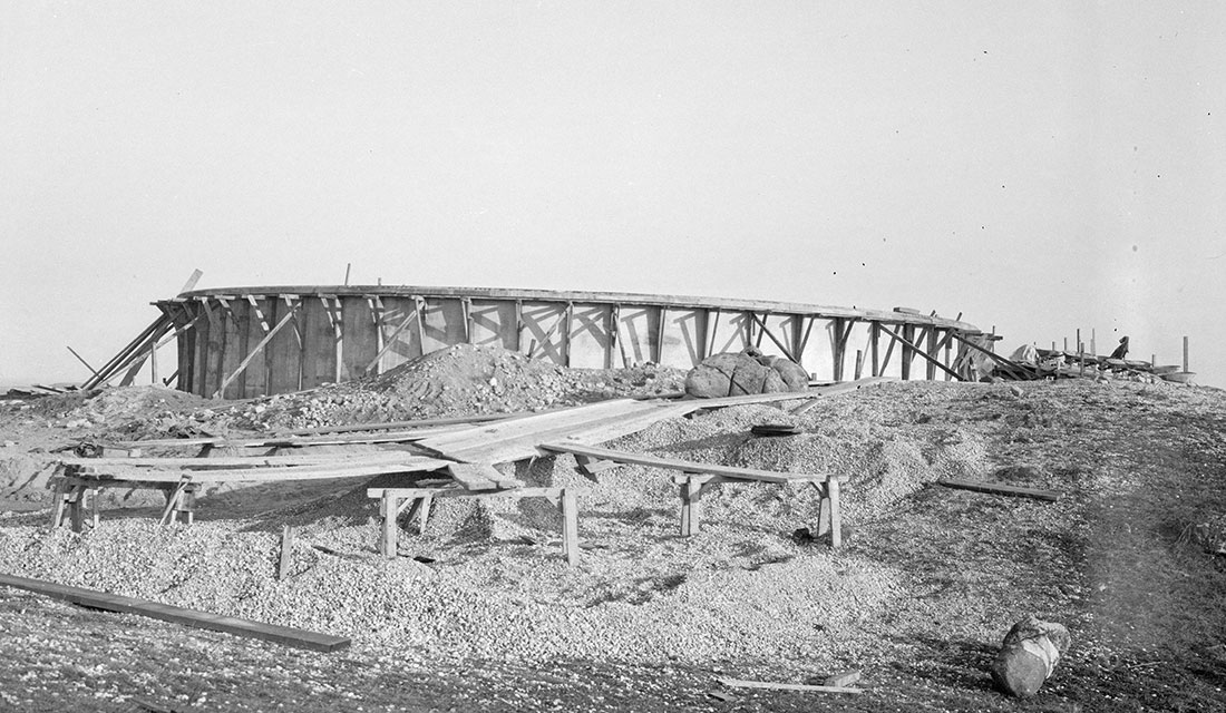
Side-angle view of the circular Chocomount Reservoir nearing completion, Fishers Island, NY
Circa 1926
Photograph by Donald F. Hine
Museum Collection. Donated by C. Clarkson Hine and Charlotte Hine Sobeck
Chocomount Reservoir has a 78 foot diameter, a depth of 15 feet and a capacity of 500,000 gallons.
The electric cable laid between Fishers Island and Groton Long Point in June 1926 brought electricity from Groton Long Point to the east end of Fishers Island for the first time.
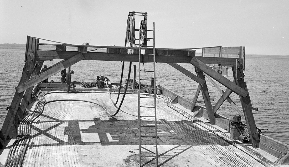
Close view of deck of the cable scow that first brought electricity to the east end of Fishers Island, NY
June 11, 1926
Photograph by Donald F. Hine
Museum Collection. Donated by C. Clarkson Hine and Charlotte Hine Sobeck
This rather nondescript scow laid the cable that brought electricity from Groton Long Point to the east end of Fishers Island for the first time. There was still 1,100 feet of leftover cable on deck after reaching Fishers Island on June 11, 1926.
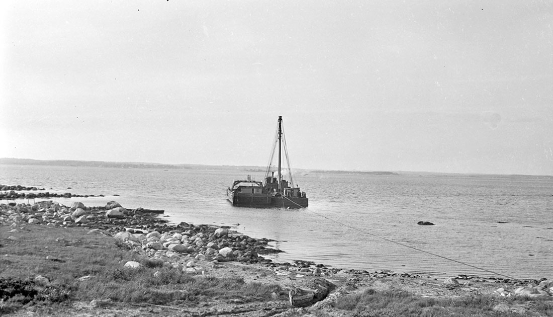
Hauling land end of electric cable ashore at Chocomount Cove on the north shore, Fishers Island, NY. (View from land.)
June 12, 1926
Photograph by Donald F. Hine
Museum Collection. Donated by C. Clarkson Hine and Charlotte Hine Sobeck

Hauling land end of electric cable ashore at Chocomount Cove, Fishers Island, NY. (View from cable scow)
June 12, 1926
Photograph by Donald F. Hine
Museum Collection. Donated by C. Clarkson Hine and Charlotte Hine Sobeck
The cable was transferred to the lighter at left to be brought ashore. The wooden sign on the cable scow says: “FISHERS ISLAND 14930 ft. 7000 Volt Cable MFG. by Safety Cable Co. June 1926.”
Please note the Chocomount Cove Electrical Substation in right center. Behind it in right background is today’s Schutz house that fronts on Middle Farm Flat (today’s driving range). The roof line of the H. L. Ferguson house “Falcon Hill” is visible above the tree line at left center (today the Collins’ house).
Trucking transformer to Chocomount Electric Power Substation, east end, Fishers Island, NY
June 8, 1926
Photograph by Donald F. Hine
Museum Collection. Donated by C. Clarkson Hine and Charlotte Hine Sobeck
This building still stands today along the shore just north of the driving range.
Workers unloading transformer at Chocomount Electric Power Substation, east end, Fishers Island, NY
June 8, 1926
Photograph by Donald F. Hine
Museum Collection. Donated by C. Clarkson Hine and Charlotte Hine Sobeck
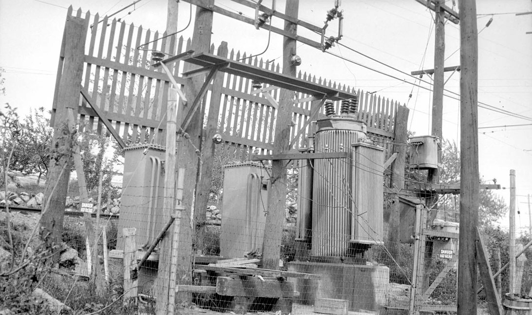
Chocomount Electric Power Substation, east end, Fishers Island, NY
June 8, 1926
Photograph by Donald F. Hine
Museum Collection. Donated by C. Clarkson Hine and Charlotte Hine Sobeck
“Trolley substation on 33,000 volt line showing one 500 KVA 33,000/2,300V transformer and three KVA 33,000/6,600V transformers.” Quote from notation by Donald F. Hine on reverse of photograph.

Repair crew splicing electric submarine cable on deck of lighter, Groton Long Point, Conn.
June 22, 1927
Photograph by Donald F. Hine
Museum Collection. Donated by C. Clarkson Hine and Charlotte Hine Sobeck
The electric cable laid between Fishers Island and Groton Long Point in June 1926 was damaged in June 1927 near the Connecticut end of the cable only 400-feet off the Groton Long Point shore. The crew seen here were making necessary repairs.
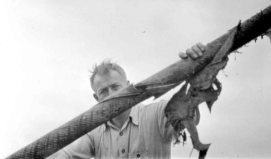
Worker inspecting damaged electric submarine cable
Circa June 1927
Photograph by Donald F. Hine
Museum Collection. Donated by C. Clarkson Hine and Charlotte Hine Sobeck
Although this photograph was not captioned by the photographer, it most likely shows the same damaged cable that is being repaired in the photograph above. The damaged section has ripped Okonite water proof coating. Electric cables were frequently damaged by boat’s anchoring in prohibited cable areas near shore.
A Plan for a Residential Colony and a New Club
In 1926, the Olmsted Brothers firm of Brookline, Mass., released the first version of their “Olmsted Plan.” It represented a victory for the developer, Frederick Ruth, who along with his fiscal sponsors, wanted to maximize land lot sales.
The first version of the Plan anticipated 500 houses on the east end: 475 new, plus 25 existing. Olmsted had lost his argument that less development meant greater value to all inhabitants within “The Park.” He strongly desired fewer land lots available for sale and more shared open space held in common.
In June 1928, a second version of “The Olmsted Plan” was released that more closely reflected Olmsted’s desire for fewer available land lots, but still appears an overdevelopment from today’s perspective.
It was the Crash of 1929 that ultimately halted land sales and gave the east end the sense of under-development that is so cherished today. It was a tragic way to achieve it, but it was the Crash of 1929 that put the Olmsted back in the Olmsted Plan.
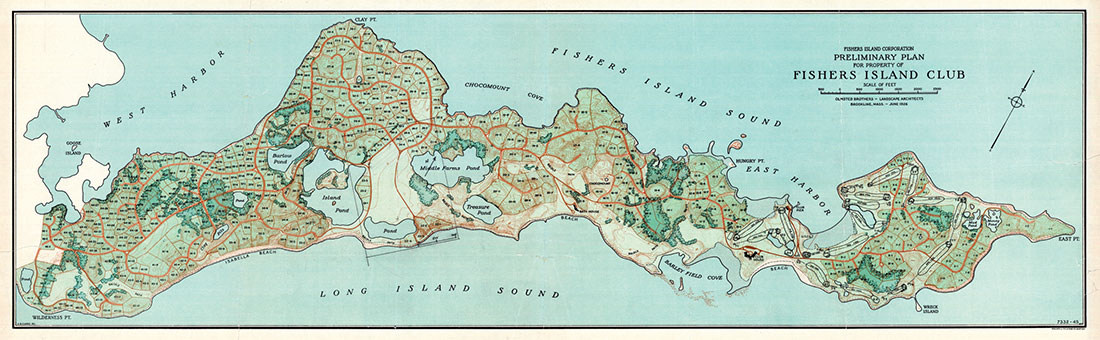
Fishers Island Corporation: Preliminary Plan for Property of Fishers Island Club
June 1926
Published by Olmsted Brothers, Brookline, Mass.
Museum Collection. Digital file donated by John S.W. Spofford

Fishers Island Corporation: Preliminary Plan for Property of Fishers Island Club
June 1928
Courtesy of National Park Service. Frederick Law Olmsted National Historic Site, Brookline, Mass.
Construction of residence of Irving W. Bonbright, east end, Fishers Island, NY
October 1926
Courtesy of National Park Service, Frederick Law Olmsted National Historic Site, Brookline, Mass.
Irving W. Bonbright, investment banker and public utilities director whose winter home was in Englewood, NJ, was one of the first to begin construction of a summer home within the new residential colony at the east end of Fishers Island. He chose a prominent site near Chocomount Hill.
Construction of Irving W. Bonbright house, east end, Fishers Island, NY
Circa 1928
Courtesy of National Park Service, Frederick Law Olmsted National Historic Site, Brookline, Mass.
This construction seems more evocative of a castle-in-creation than a typical summer residence. During the mid- to-late 1920s, the scattered clusters of simple farm houses and work-related structures that had characterized the east end were quickly eclipsed by dozens of substantive summer residences under construction within “The Park.”

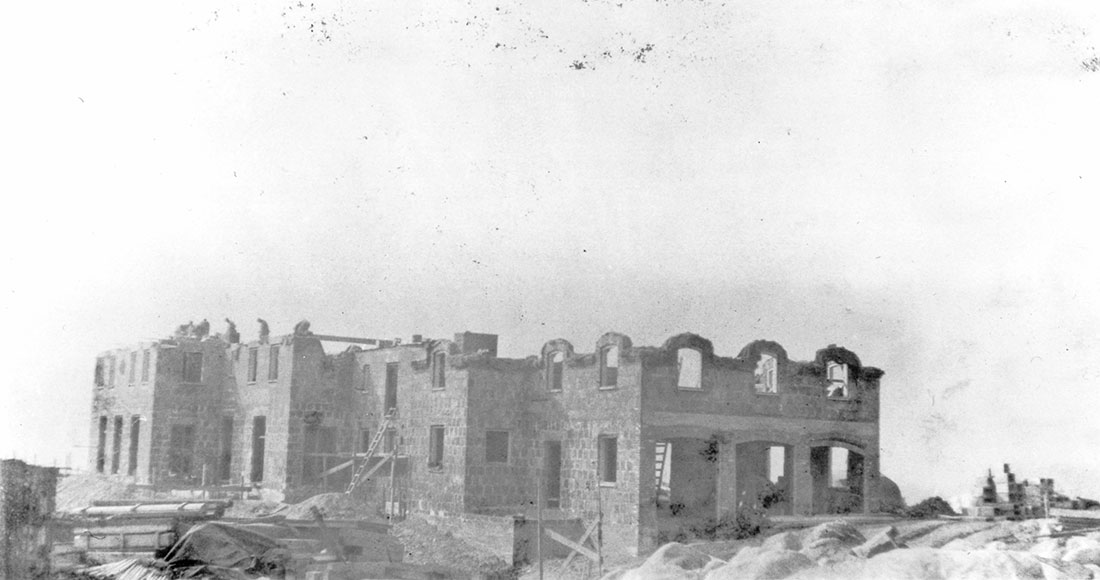
Construction of Irving W. Bonbright house, east end, Fishers Island, NY
Circa 1928
Photograph by Donald F. Hine
Museum Collection. Donated by C. Clarkson Hine and Charlotte Hine Sobeck
As this photo clearly documents, the east end’s landscape was still quite clear of vegetation in the late 1920s. However, the cessation of sheep farming in 1914, and the shutting down of almost all island farming by 1924, led to the slow but steady growth of plants, trees, and underbrush that has totally transformed the island’s landscape and our perception of it. Both natural processes and deliberate plantings are responsible for what appears today to be an explosion in vegetative growth, including many invasive plants.
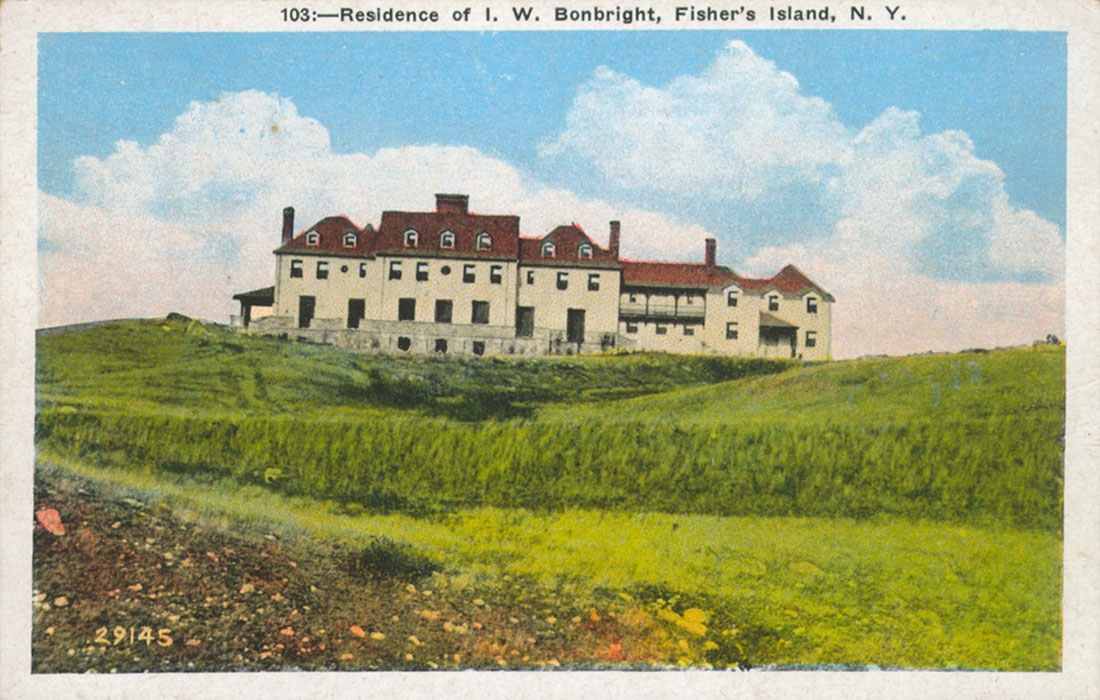
“Residence of I.W. Bonbright, Fisher’s Island, N.Y.”
Circa 1930s
Postcard published by J. Solomon, New London, Conn.
Museum Collection
The architect of Bonbright’s house, Franklin Abbott, had no intention of harmoniously blending, or submerging this residence into the landscape the way so many other contemporaneous houses were on the east end. Quite to the contrary, he placed it on its own man-made podium near Chocomount Hill, so that it presented its almost imperial facade to the surrounding countryside. However, despite the architect’s original intentions, today this house is all but obscured by surrounding vegetation.
For many years a Firestone house, the Bonbright house is now owned by the Kuijpers family.
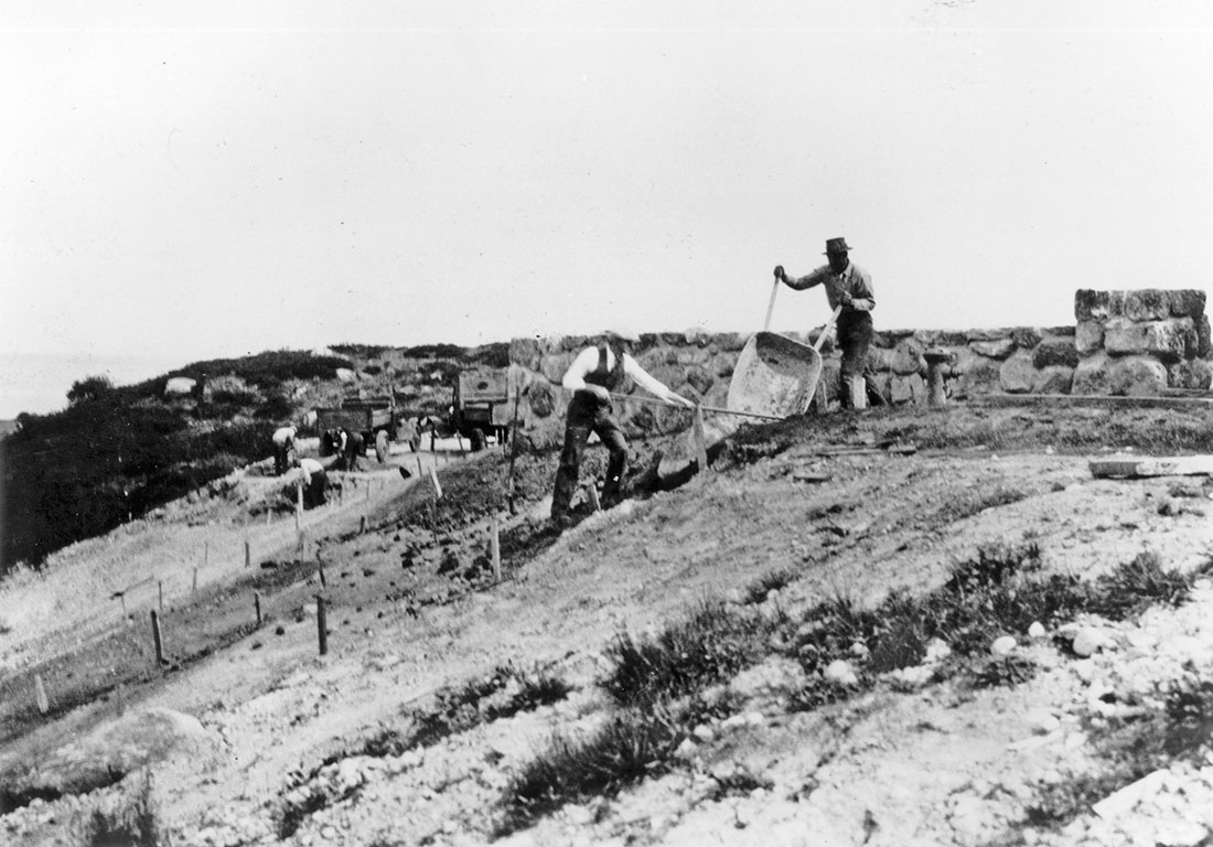
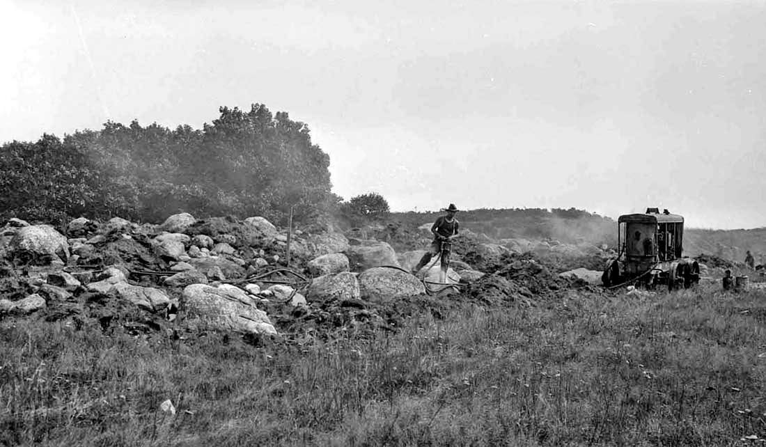
Rocks removed from the 6th fairway during construction of the Fishers Island Club’s golf course
September 1, 1925
Photograph by Donald F. Hine
Museum Collection. Donated by C. Clarkson Hine and Charlotte Hine Sobeck
Rocks removed from the 6th fairway during construction of the Fishers Island Club’s golf course
September 1, 1925
Photograph by Donald F. Hine
Museum Collection. Donated by C. Clarkson Hine and Charlotte Hine Sobeck
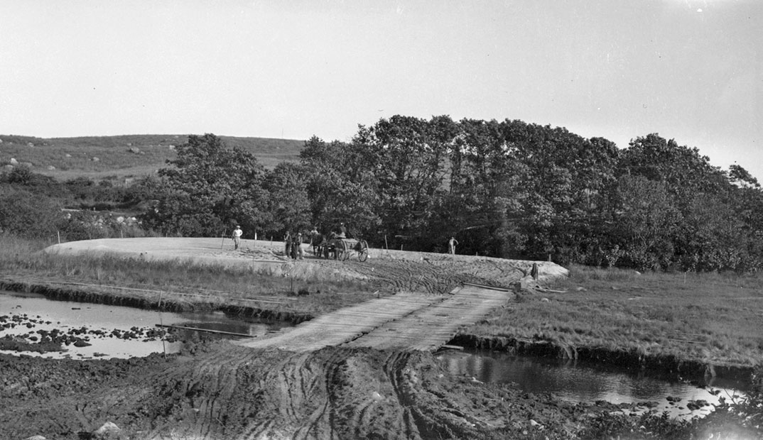
Crew with filling for 14th green during construction of Fishers Island Club’s golf course
September 27, 1925
Photograph by Donald F. Hine
Museum Collection. Donated by C. Clarkson Hine and Charlotte Hine Sobeck
Please note the mule- or horse-drawn wagon that is on the green. It is rumored that during the construction of this hole, a mule-drawn wagon sank and was lost to the neighboring swamp.
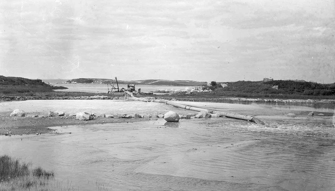
Pumping sand fill for 16th green during construction of the Fishers Island Club’s golf course
August 1925
Photograph by Donald F. Sine
Museum Collection. Donated by C. Clarkson Hine and Charlotte Hine Sobeck
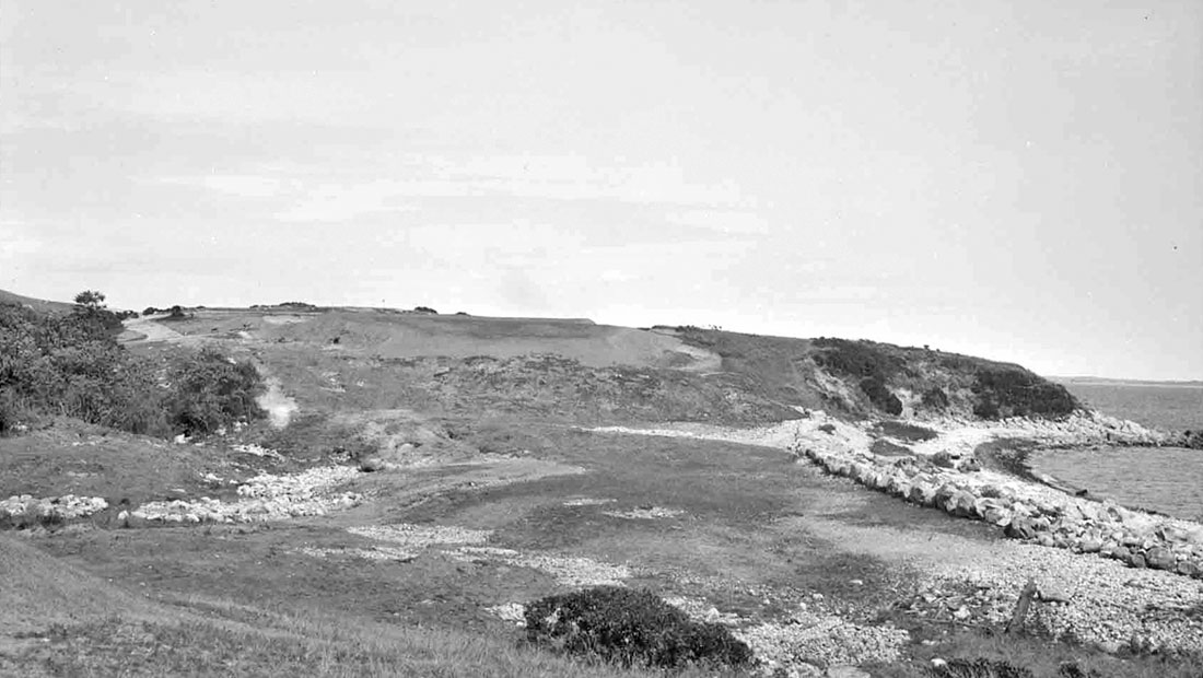
5th fairway and green during construction of the Fishers Island Club’s golf course
September 20, 1925
Photograph by Donald F. Sine
Museum Collection. Donated by C. Clarkson Hine and Charlotte Hine Sobeck
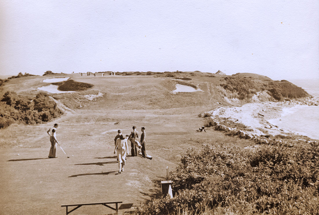
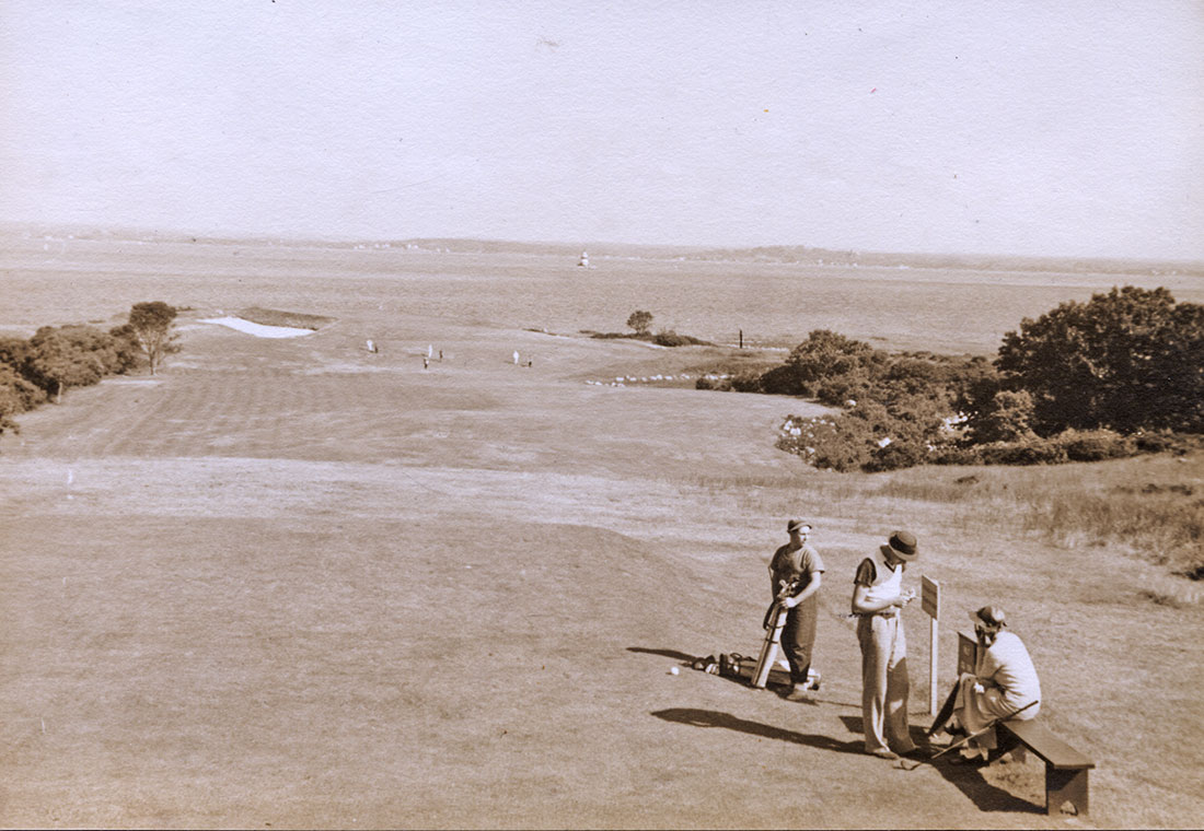
Golfers on tee of the 5th hole of the Fishers Island Club’s golf course
Circa 1936
Photograph by Grant Simmons, Sr.
Museum Collection. Donated by Harry and Susie Ferguson
The Fishers Island Club’s golf course opened on July 1, 1926.
Please compare this completed golf hole with the previous image that shows its prior state during construction.
Work crews clearing stones from the 7th fairway of the Fishers Island Club’s golf course during construction
September 1, 1925
Photograph by Donald F. Hine
Museum Collection. Donated by C. Clarkson Hine and Charlotte Hine Sobeck
Golfers on tee of the 7th hole of the Fishers Island Club’s golf course
Circa 1936
Photograph by Grant Simmons, Sr.
Museum Collection. Donated by Harry and Susie Ferguson
Please compare this completed golf hole with the previous image that shows its prior state during construction.
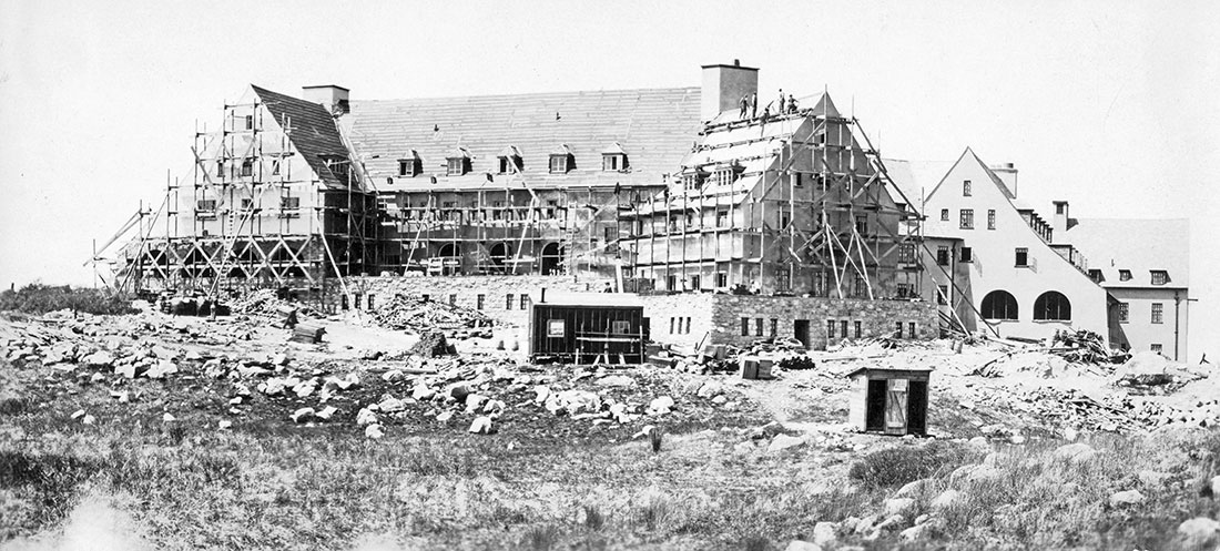
Fishers Island Club’s clubhouse under construction
May 9, 1926
Photograph by Parsons & Wait, Architects, Boston, Mass.
Museum Collection. Donated by Fishers Island Club
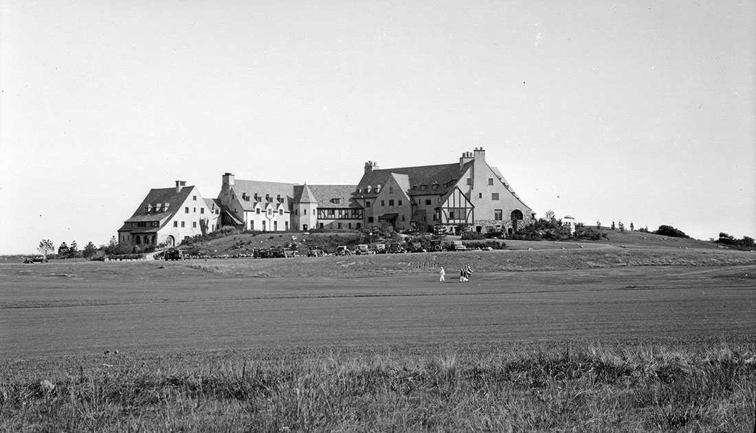
Wide view of Fishers Island Club’s clubhouse as seen from golf course
September 1928
Photograph by Donald F. Hine
Museum Collection. Donated by C. Clarkson Hine and Charlotte Hine Sobeck
The Fishers Island Club’s clubhouse officially opened on July 1, 1926.
This image makes it easy to imagine how the Fishers Island Club got its “Big Club” nickname. The distinctive Norman Farmhouse-style building remained in active use for 37 years, including several years during World War II when it functioned ostensibly as a Navy Training Center, but doubled as a base camp for secret harbor-floor sonar experiments.
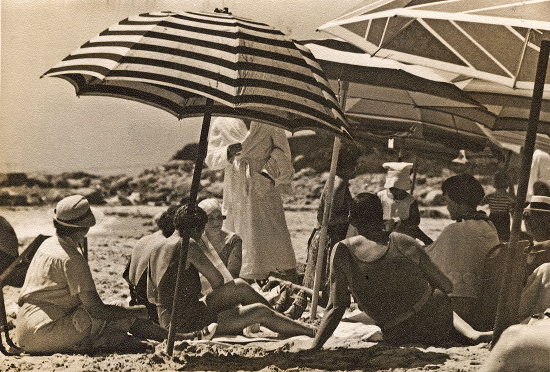
People relaxing under umbrellas at Club Beach, Fishers Island Club
Circa 1936
Photograph by Grant Simmons, Sr.
Museum Collection. Donated by Harry and Susie Ferguson
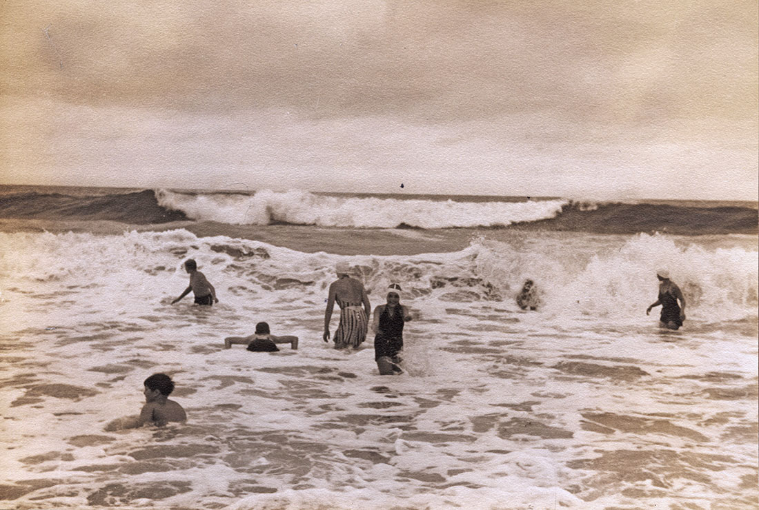
Enjoying the big waves at Club Beach, Fishers Island Club
Circa 1936
Photograph by Grant Simmons, Sr.
Museum Collection. Donated by Harry and Susie Ferguson
The Fishers Island Club distinctive Norman Farmhouse-style building remained in active use for 37 years, including several years during World War II when it functioned ostensibly as a Navy Training Center, but doubled as a base camp for secret harbor-floor sonar experiments.
In 1963, the Club’s Board of Governors determined that it was too costly to operate and authorized its destruction. Following a failed attempt to blow it up with dynamite, this spectacularly grand structure was intentionally destroyed by fire on September 19, 1963.
The 2015 Annual exhibition was sponsored by ALTUS Partners & CHUBB
The digitizing of this 2015 Special Exhibit for online viewing has been made possible thanks to a generous grant from the Jeanann Gray Dunlap Foundation.