Mapping the Future:
Advancing Eelgrass Monitoring in Long Island Sound
by Hannah Vagts, Project Manager, FISMC

Eelgrass (Zostera marina) is essential to coastal ecosystems like Long Island Sound. Eelgrass meadows provide critical habitat for numerous marine species and contribute to improved water quality, reduced coastal erosion, and carbon sequestration. Understanding the location of eelgrass is the essential first step in assessing the factors that affect its survival. Historical nautical maps from the 19th century first documented its extent. However, a significant decline in the 1930s due to wasting disease highlighted the need for reliable mapping methods. Initially, researchers used historical photos and small-scale surveys, but by the 1960s, aerial photography became the primary technique, capturing images from planes to identify eelgrass locations. The resulting hundreds of individual photos are stitched together to create a single large aerial photo mosaic of an area of interest, such as Long Island Sound. After scientists manually mark eelgrass areas on the photo, ground truthing is performed to verify these areas. Aerial photography is expensive and time-consuming, so this method of eelgrass mapping occurs infrequently (approximately every 5 years).
In recent years, several organizations in Long Island Sound have sought to develop more cost-effective, accurate, and time-efficient methodologies for consistent monitoring of eelgrass extent. Low-resolution satellite imagery is much easier but less accurate than aerial imagery. Drone imagery and acoustic sonar are accurate but time-consuming and best suited for smaller-scale projects.
The Fishers Island Seagrass Management Coalition (FISMC) is pioneering a new and revolutionary approach: high-resolution satellite imagery. The images have the same resolution as aerial photographs at a fraction of the time and cost. This is the third consecutive year mapping eelgrass around Fishers Island and due to our success, we have expanded to include parts of Connecticut as well. In 2026, FISMC will publish maps covering over 90% of all eelgrass in Long Island Sound.
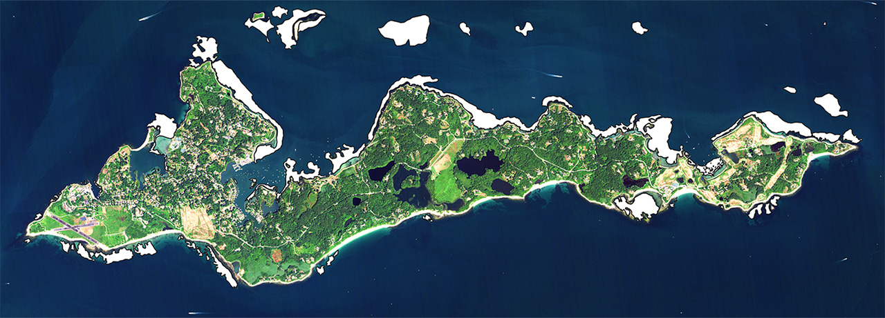
Satellite image of F.I. taken August 2025 with eelgrass areas marked in white.
Although satellite imagery is less expensive than aerial images, it still comes with a large price tag; each image costs roughly $3,500. Therefore, I am very particular about the parameters. Each photo needs these “stars” to align:
- Cloud Cover: Nothing ruins a photo faster than clouds!
- Heat Index: Have you noticed waves of heat rising from the pavement? Imagine seeing that from space.
- Tides: Taking photos at low tide solves two issues: 1) it standardizes a variable for statistical analysis, and 2) it maximizes what we can see underwater.
- Sea Conditions: Big, crashing waves can obscure what might be visible underwater.
- Wind: Slower wind speeds calm both the land and seascape.
- Air Quality: Wildfires can produce smoke clouds that obscure the photo.
When I find an optimal weather window, I check in with our satellites, which move in predetermined orbits. These orbits make the satellites available only at specific times of the day. I track the satellite to determine its orbit and when it will be above our area. With a bit of luck, I can find a satellite orbit that matches our weather window. If everything aligns, I check one final parameter: the sun angle. This parameter is important because light interacts differently with surfaces at various angles. If the sun angle is acceptable, I send code to the satellite to take the photo with at least five hours’ advance notice. Once the satellite is scheduled, I cannot retract the request if the weather window worsens. So, for several hours, I cross my fingers and try not to check the weather, the one time my browser is blissfully clear of weather, tide, and wildfire-tracking tabs.
To date, I have captured 18 perfect, cloud-free satellite photos and one photo with 6% cloud cover.
The additional longitudinal data ensures we fully understand trends in eelgrass extent. It also enables us to detect previously unmarked eelgrass areas, a remarkable leap in our research and mapping capabilities. This knowledge is the foundation for more detailed assessments of eelgrass health and distribution in the years to come. This is a promising journey, as we seek to transform these insights into conservation strategies that foster habitat restoration and bolster the resilience of coastal ecosystems. We are committed to uncovering knowledge that not only benefits the environment but also uplifts our Fishers Island community that is so connected to these vital habitats.The additional longitudinal data ensures we fully understand trends in eelgrass extent. It also enables us to detect previously unmarked eelgrass areas, a remarkable leap in our research and mapping capabilities. This knowledge is the foundation for more detailed assessments of eelgrass health and distribution in the years to come. This is a promising journey, as we seek to transform these insights into conservation strategies that foster habitat restoration and bolster the resilience of coastal ecosystems. We are committed to uncovering knowledge that not only benefits the environment but also uplifts our Fishers Island community that is so connected to these vital habitats.