Birds are quite literally both marvelous and wonderful. We marvel, with no small dose of envy, at their ability to fly, and we wonder, among many other things, what happens to so many of them in the winter. For millennia, the mysteries of migration—Where do birds go? How do they find their way to and from their wintering ground? How long does it take to get there and back again?—have remained inscrutable.

Osprey Studies in the Age of Silicon
The Early Studies
The first clues about where birds travel came from birds marked simply for identification. While out hawking one day in 1595 King Henry IV’s Peregrine Falcon disappeared chasing a bustard. Some time later, it was found on the Isle of Malta, 1,350 miles away. In a particularly bizarre example, a stork appeared one spring in the middle east with a Masai spear in it—a macabre indication of where it had been over the winter.
John James Audubon was the first person we know of to mark a bird specifically to learn about its migration. In the first decade of the 19th century, he tied silk threads around the legs of Eastern Phoebes nesting at his Pennsylvania farm and thus was able to recognize these same birds returning the following spring. A small, but key piece of the puzzle fell into place—at least in this species, the same birds come back to the nest each year.
At the turn of the 20th century, scientists began marking birds systematically. Uniquely numbered metal bands were placed on their legs. The recovery of these bands showed us where the banded birds traveled after they were banded and told us how long they lived, but we were still left with a myriad of questions unanswered. Among the more obvious were: What routes did they take to get to the places where they were encountered? When did they arrive there? Was the band recovery location their final destination or a stop along their way to some more southerly winter home? Do families travel together?
Back in those dark ages (pre-satellite transmitters), nearly 30,000 Ospreys were banded in North America. Being a large and conspicuous bird, the recovery rate for banded Ospreys was high enough that we developed a good picture of how migration works in Ospreys. Almost all east coast and Midwest Ospreys spend their winters in South America. Females leave their nesting territories in August, two to three weeks before the males and juveniles. Interestingly, juveniles seemed to spend an extra year on the wintering grounds, eschewing a return trip north in their first spring. As all the adults head to their nesting grounds, the young stay put, avoiding the needless risks of another migration—they don’t breed until they’re 3 or 4 years old. Band recoveries paint an overland path for these birds from their nesting grounds to Florida. From the Keys, band returns indicate that they island hop, staying over land as much as possible through Cuba to Hispaniola and then head down to South America. Based on banding data, it looks as if most North American Ospreys winter in the Cauca and Magdalena valleys of Colombia, with some spread out over much of northern South America and a very few birds reaching as far south as Argentina.
Information from banded birds requires, obviously, someone finding the banded bird, and that usually means the bird is dead. This introduces some biases into the data that could affect our picture of Osprey migration. How often do Ospreys go out over the Atlantic at any point on their route to the Caribbean? We know they sometimes do, because they have been reported on Bermuda, but how common is this? It’s very unlikely that we would get a band recovered off shore, so are all the Ospreys that leave Florida really island-hopping, or do some of them just head south from Cuba and cross the Caribbean? We can’t tell this from band recoveries, because we’re not going to find an Osprey that dies out over open water. Is there a real concentration of wintering Ospreys in northern Colombia, or is this the result of a higher human population density there resulting in more band recoveries there than in the vast and much more sparsely populated rainforests of Amazonia?
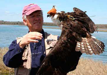
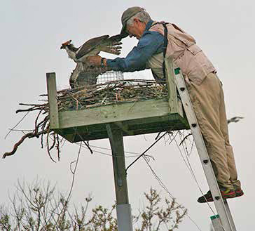
Rob Bierregaard adjusting transmitter on Osprey “Raphael.”
Silicon to the Rescue!
It wasn’t until late in the 20th century that technology provided a way to answer these and many other questions about bird migration that had long seemed forever out of our reach.
In the late 1970s, scientists began tagging animals with radios that could send signals to satellites. The source of those signals could be located, so the scientists could track their tagged study subjects. The first radios deployed were huge and only very large animals such as elk or caribou could carry them.
Like all things electronic in these silicon-based days, the transmitters rapidly became smaller and smaller. (Unfortunately but understandably, because the market for tracking devices to deploy on birds is a rather limited one, prices have not followed the “getting cheaper” part of Moore’s Law.) As the transmitters became smaller, we could put them on smaller and smaller birds. By the mid 1990s, satellite transmitters were being produced that weighed just a bit more than an ounce and could send a signal to a satellite orbiting 540 miles overhead! This opened the doors to remote tracking of Ospreys. (The standard practice is that we don’t put anything on a bird that weighs more than 3% of the bird’s body weight, and a one-ounce transmitter passes this test on the smallest Ospreys—males—which weigh between 2.4 and 3.5 lbs.)
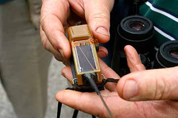
Closeup of Edwin’s one-ounce transmitter. 5/11/13. Photo by John Ski.
The first transmitters simply sent a radio signal up to a satellite with some very basic data about the transmitter itself: its ID number, some information about whether the transmitter (and consequently the bird) was still moving, and some engineering data about the state of the transmitter itself. Because the satellites receiving these signals are moving at a very high speed and the transmitter is relatively stationary, the frequency of the signal received at the satellite will be higher as the satellite approaches the transmitter and lower as it flies away from it. (If you don’t remember it from a physics class, you’ve probably noticed this phenomenon—the Doppler Shift—when a siren passes you on the highway.) A computer program uses some fancy trigonometry (and probably a couple of second derivatives) to determine where the signal was coming from based on the difference between the frequency that transmitter should be emitting and the frequency perceived at the satellite.
The locations are fairly accurate—down to about 100 yards in ideal circumstances, but more often to within a mile or so. Not bad from 540 miles away! And that’s all we need to follow birds on migration. With that level of accuracy we can tell when they start and stop migrating, the route they take, and where they spend the winter, but we cannot use the data to really understand how the birds are using their local environment. To get to that level of detail, we had to wait for GPS units to be incorporated into the transmitters.
The wait was not long. In 2001, Microwave Telemetry, our supplier and the leader in the field, manufactured their first GPS transmitter. At the same time, they introduced another very important innovation to the transmitters—solar charged batteries. This greatly increased the expected lifespan of the transmitters, enabling us to follow multiple migration cycles by the same individual. The first GPS unit weighed almost 3 ounces—too heavy for an Osprey. It took a few years before they were able to make them small enough for our birds.
Once we deployed these tiny GPS devices on Ospreys, we could get pinpoint accuracy on the locations. Instead of knowing where our birds were to within 100 yards or a few miles, we could virtually determine in which tree they perched, and more importantly, what body of water they were fishing. The GPS data also include speed, direction, and altitude for each hourly location, so we can look at how local weather affects migration.
Remarkable as the GPS satellite data was, we were still limited. For various technological reasons relating to getting a 1-ounce device talking to a satellite, we could only get 12 hourly locations per day. While this was light years ahead of the old Doppler units, we weren’t satisfied. (You can never have too much data!) With locations taken every hour, we could miss an entire hunting expedition. If a bird left its nest at 1:05
and brought back a fish at 1:55, all we would see were two data points (1:00 and 2:00 PM) at the nest, and the fishing trip would be invisible to us. Conversely, if we saw a bird heading away from its nest at 1:05 and coming back at 1:55, we couldn’t tell where the bird had gone.
The scientists and engineers working on these transmitters solved this problem by literally bringing the communication system down to earth. Instead of using satellites to receive the data, we can now get data from our tagged birds via cell-phone towers. This requires much less energy from the transmitter, so we can get amazing amounts of data. Given a fully charged transmitter, we can get locations every two minutes! Now our
Ospreys have no place to hide—we can monitor their every move, especially around the breeding grounds.
Osprey Tracks
Osprey tracking via satellite with the Doppler transmitters began in 1995 in Sweden. From 1995 through 2012, 244 Ospreys were tagged in North America and about 140 in Europe.
I got into satellite tracking in 2000, pretty much at the tail end of the big push to tag Ospreys with Doppler transmitters. After 2003 I had tagged a modest six adult Ospreys. At that point we already had such a great picture of the migration from the old Doppler transmitters that we really wouldn’t learn anything new by tagging more adults, so I switched my focus to tracking juveniles.
In 2007 I began using the new GPS transmitters on juveniles and realized that the new technology offered us an opportunity to fill in a lot of gaps in our knowledge of the feeding habits of the adult males around their nests. So in 2009, I once again began tagging adult male Ospreys.
Why males? Once a pair of Ospreys has returned to its nest and laid eggs, the female is pretty much glued to the nest. Except for brief respites when the male brings her a fish and takes over incubation for a half hour or so, the female is on the nest almost nonstop for about eight to nine weeks. She has to incubate the eggs and keep the young warm on the cool days, cool on the hot days, and dry on the rainy days. While she has her talons full with all those duties, the male is working overtime providing all the fish that the family—the male, the female, and up to four voracious young—will need during that period.
Thus the success of the pair is fully on the shoulders of the male. And so these are the birds to tag if we want to understand how Ospreys use the environment around them in their one and only job, which simply put is turning fish into new Ospreys.
So what have we learned about Osprey migration from all these tagged birds? Do these data change what we concluded based on the banding data?
The early Doppler data, collected mostly by Mark Martell, then working at The Raptor Center at the University of Minnesota, came from 74 Ospreys tagged on the east coast, the Midwest, and the Pacific northwest.
Mark and his colleagues showed, to no one’s surprise, that the big picture we’d deduced from the banding data was basically sound. The satellite data however, also to no one’s surprise, filled in many details and answered some of the questions that banding recoveries could not address.
Males and females leave the nesting areas at different times—females in mid-August and males and juveniles in September—and go to different places. Females tend to migrate further south than males. Banding returns had already hinted at that, but now we knew. Mark tagged one family (both adults and two young) in Minnesota. The satellite tracks showed that one of the adults flew to South America via Florida and the Caribbean, while the other stayed over land and got to South America via Mexico and Central America. The two young flew—separately—down the Mississippi and over the Gulf of Mexico to the Yucatan. So families most definitely do not travel together!
A comparison of the winter locations of satellite-tagged birds with banding returns tells us that the banding returns are definitely biased. Satellite-tagged birds spread out very evenly over much of the northern half of South America, so those clusters of recoveries up in northern Colombia were just there because more Ospreys were found, not because more Ospreys spend their winters there.
The tracks from Mark’s tagged birds showed that virtually all the East Coast Ospreys and many of the Midwestern birds travel down what Mark calls the Osprey Highway to the Tropics— Florida to Cuba to Hispaniola to South America. Almost no Ospreys flew from Cuba to Central or South America.
East Coast birds, when heading south with a wind out of the west will get to the Outer Banks of North Carolina and fly over open water (the Georgia Bight) to Florida—a distance of some 500 miles. We would never have known this from banding returns.
Ospreys heading south from the Midwest and East Coast populations average about 130 miles/day, which includes occasional stopovers of as much as 3 weeks. On a normal migration day, their ground speed will be between 20 and 30 mph.
They almost never migrate at night over land, but they do migrate at night over water. This really comes as no surprise, as their crossing from Hispaniola to South America usually takes at least 16 hours. They can’t alight on the water and rest as a gull could, so once they’re out over the water, they’re in the air for the duration. Some of our juveniles tagged on Martha’s Vineyard cross over 1,000 miles of the Atlantic before they get to the Bahamas (they don’t know any better). These nonstop flights can last more than 50 hours, so the birds are flying through the night twice without a break!
Besides showing us the routes and timing that migrating Ospreys use, when we have a bird survive the migration cycle and head south for a second time, we get important insights into their navigational system. All birds that have been followed for more than one migration cycle return faithfully to exactly the same place every winter. However, they do not take the same route each year. An individual can arrive in South America 300 miles east or west of where they made landfall in South America the previous year, probably in an area they’ve never seen before. And yet as soon as they head inland, they somehow know where they are relative to their winter destination. They then make the appropriate adjustments in their route and work their way unerringly to the remote mountain valley or tributary of a tributary of the Amazon out in the trackless expanses of the world’s largest rainforest. The important implication of these different routes across years is that they don’t use landmarks to navigate, so they must be using some cues from the Earth’s magnetic field.
The GPS and cell-tower data from adult males is full of surprises. It’s early days still with these transmitters, but we can already see remarkable differences in the behavior of neighboring males over on the Westport River colony in southeastern MA, where we have had as many as three males tagged simultaneously. Not surprisingly, early in the spring when the herring are running up the East Branch, all the birds are up there taking advantage of the all-you-can-eat smorgasbord. Once the herring stop running, each bird heads off to hunt his own particular combination of fishing holes—mostly freshwater ponds. One of the birds was flying 20 miles one-way to fish off Jamestown, RI.
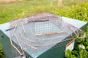
The trap with fish-line “nooses” on top that entangle the bird’s toes. Photo by John Ski.
We see other shifts in fishing locations as different fish species— menhaden and bluefish, for example—move into and out of the neighborhood of our tagged males.
Thanks to the efforts of the Henry L. Ferguson Museum and the Spofford Foundation, Fishers Island joined the study this spring. Using one of the new cell-tower transmitters, we tagged an adult male, named “Edwin,” in honor of Fishers Island teacher and Ferguson Museum naturalist Edwin Horning, in the Middle Farm/Beach Pond area of the island. I think all involved (Edwin himself excluded) were amazed to see that Edwin is commuting more than 10 miles each way to get apparently all his fish around and just west of the mouth of the Niantic River!
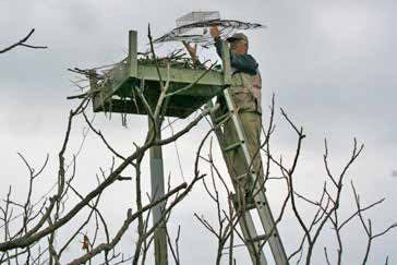
Rob Bierregaard setting the trap over the nest. Photo by John Ski.
2013 is a big year for tagging adult males. Including Edwin, I have tagged 11 new males this year and have three others tagged from previous years. New birds in the study range from the middle of the Chesapeake Bay to northern New Hampshire—a span of about 525 miles.
If all goes well, next year we will deploy at least two more transmitters on Fishers Island Ospreys.
Details of my research and annotated maps for this year’s and all previously tagged birds can be found on line at: http://www.bioweb.uncc.edu/bierregaard/.
Edwin being retrieved from trap. Photo by John Ski.
Edwin’s maps and data can be found on the
“Track Edwin” page of the museum website.
Richard O. “Rob” Bierregaard, Jr., a resident of Pennsylvania, is the Distinguished Visiting Professor in the Department of Biology, University of North Carolina, Charlotte.